| Places:County Maps Arenac County Map
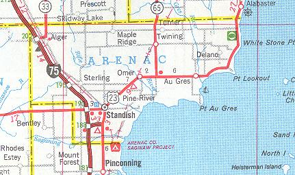
from the Michigan Department of Transportation State
Highway Map - 1999
County Historical Maps
Arenac County Sections of Historical State Maps
use your browser's "back" button to return to this page from
linked graphics files
1. 1874 - When Arenac County was
a part of Bay County - 69kb
"RR Maps of Michigan prepared for the Comissioner of Railroads"
G. W. & C. B. Colton & Co.
Philadelphia 1876, c1874
from the Library of Congress, Geography and Map Division - LC RR
Maps #238
2. 1885 - The early years of the
county - 76kb
"Official map of Michigan, railroad, township and sectional, prepared under
the direction of the commissioner of railroads."
Cram & Stebbins
Chicago 1885
from the Library of Congress, Geography and Map Division - LC RR
Maps #239
3. 1886 - The early years of the
county - 72kb
"Map of Michigan showing the Toledo, Ann Arbor, & North Michigan Railway and
connecting lines"
G. W. & C. B. Colton & Co.
New York 1886
from the Library of Congress, Geography and Map Division - LC RR
Maps #583
Up to top
This site (c) 2000-2017. |