 |

|
|
in Lapeer County, MI |
|
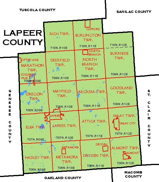
As it is currently configured, Lapeer county is roughly a 24-by-30-mile rectangle, with pieces cut out of the NW and NE corners. This is divided into 6-mile horizontal "Township" tiers, numbered 6N, 7N, 8N, 9N and 10N, and vertical "Range" columns, numbered 9E, 10E, 11E and 12E. The word "Township" or "Town" is also used for the 6-by-6 squares thus produced. (The exception is Burnside Township, which has a little extra.) Thus the square T6N, R12E is also known as Almont Township, or the Town of Almont. So the village called Almont lies within the Town of Almont. The county has 663 square miles in 18 townships, each comprising about 36 square miles, except Burnside with 54. The townships are further divided into 1-square-mile sections, generally numbered from 1 to 36. The names and boundaries were changed many times, and took their final form, shown in the map below, in 1869.
When the county was created in 1822, it had 27 of these 6-by-6-mile square blocks. After some reorganization, some of this area went to surrounding counties. Originally, there were only 3 townships, which were organized even before the county government. Grand Blanc Township, organized 9 Mar 1833, was comprised of 5 of the blocks. When Genesee County was formed on 28 Mar 1835, Grand Blanc Township became part. Since it was with Lapeer only 2 years, I am not including it here. The 2nd township, organized on 7 Mar 1834, was called Mia, but the name was changed to Bristol on 12 Dec 1834, and changed to Almont on 7 Apr 1846. It was made up up what eventually became the townships of Almont and Imlay. The first township meeting was held at the house of Daniel BLACK. The first land entry in the county was in Imlay, made on 12 Dec 1825, by Calvin C. PARKS and John K. SMITH, of Oakland County. Several land speculators purchased land from the government, but never lived on the land. The first actual white settler in the county was James DENEEN, of Trumbull County, OH, who settled in Almont Township. Lapeer Township was organized on 30 Dec 1834, and originally included all of the present area, plus Grand Blanc on the west side, which bacame part of Genesee County on 28 Mar 1835. The first township meeting was held at the house of E. H. HIGLEY. The links below give information on each township and village, of interest to genealogical researchers. The dates show the history of boundary and name changes. For example, the area now called Rich Township was originally part of Lapeer Township, formed 30 Dec 1834, then became part of Deerfield Township on 18 Dec 1855, and became Rich Township on 1 Dec 1859.
Goodland Township on Wikipedia Names of property owners can be seen on the 1863, 1874, 1893, 1906 and 1921 plat maps. See the Maps page for links to these. |
|
This page was last revised 1 Oct 2025.
Lapeer County MIGenWeb contents have been willed to MIGenWeb. |