Plains Cemetery

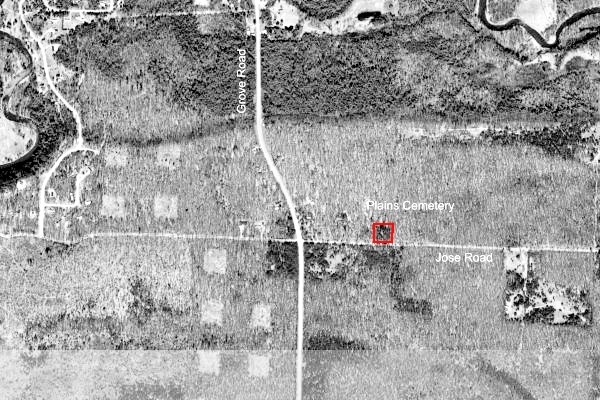
Plains Cemetery is Section 2 Deep River Township. Although closest to Omer, the cemetery is equally accessible from either Omer or Standish. The locale apparently was a logging site along the Rifle River. There’s no indication of headstones, no known records about those buried there.
- From Omer, follow US-23 southwest for about two miles. Turn west on Sterling Rd for about two miles, then go north on Grove Rd for about four and one-half miles. Turn east onto Jose Rd for about one-third mile. The cemetery is on the left.
- From Standish on US-23, turn north onto Grove St/N Grove St for about six and on-quarter miles. Turn east onto Jose Rd for about one-third mile. The cemetery is on the left.
Even though the interred are unknown, a veterans ceremony is held there each Memorial Day.
Contact Deep River Township supervisor
GPS coordinates for Plains Cemetery: 44.070231, -83.958519
Aerial photo1 | No known section map
Plains Cemetery burial information
An entry for John Brayton Irish (1825-1887) is listed on FindAGrave.com, but officially there are no headstones and no known record of deaths or burials associated with the cemetery.
If you have any history, family stories or sources (either original or derivative!) about an individual associated with the history of the Plains Cemetery location or a burial in the cemetery, please contact the MiGenWeb/Arenac County coordinator. We’d be happy to hear about it.
Online resources
- Plains Cemetery @ FindAGrave.com
- Plains Cemetery Topo Map @ AnyplaceAmerica.com
Media Credit
1. Aerial view Plains Cemetery GPS approximately 44.070231, -83.958519. Date unknown. Photo source USGS
USGenWeb Notice: In keeping with our policy of providing free information on the Internet, data may be freely used by non-commercial entities, as long as this message remains on all copied material. These electronic pages may NOT be reproduced in any format for profit or presentation by other organizations.